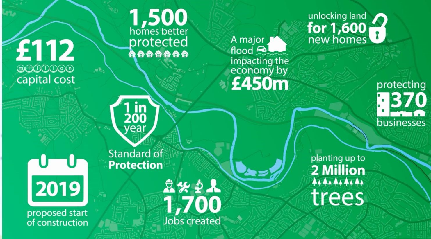
Phase two of the £112 million Leeds flood defence scheme is one of the largest river flood alleviation scheme in the UK. It will be carried out in two steps so that progress can start to be made as soon as possible using government funding currently available, alongside other financial support from the council and partners.
Step one
Flood wall works will start in autumn 2019 on this first step to deliver an initial level of protection against the threat of flooding from the River Aire which equates to a 1 in 100 (1%) chance of flooding in any given year. These works are located between Leeds City Centre and Newlay.
It also incorporates a flagship catchment wide Natural Flood Management programme alongside engineering works. This will involve working with partners and land owners to deliver a range of measures, such as the creation of new woodland, woody debris dams and wetland, which can slow the flow of rainwater into the river, helping to reduce the risk of flooding and the impacts of climate change.
Step two
Step two of the package will be an upgrade to a 1 in 200 (0.5%) chance of flooding in any given year, once the remainder of the funding has been secured - making Leeds Flood Alleviation Scheme one of the largest flood defence schemes to be constructed in the country.
It will include:-
- The creation of a flood storage area near Calverley
- Flood alleviation measures to areas of Woodhouse Grove School and also Apperley Bridge in the Bradford District.
Once both steps are complete, 1,048 homes and 474 businesses will be better protected.
A separate planning application has also been submitted to carry out landscape works as part of phase two of the scheme will benefit the environment and wildlife, and improve access to amenities. This will include two new bridges, improvements to footpaths and new woodland and natural areas.
On 27 March 2019 Leeds City Council declared a climate emergency with the intention for the city to be carbon neutral by 2030. Leeds Flood Alleviation Scheme (FAS) Phase 2 recognises that as a large engineering project we have a responsibility to reduce our impact on the environment. This can be achieved in a number of ways - for example, by using low carbon concrete, which is up to 40% lower than is typical. Digital construction methods such as 3D modelling will identify opportunities to reduce CO2 ahead of construction. The project is also aiming to reuse 95% of site-won material.
See the downloads below for maps showing the areas of Leeds for Steps 1 and 2, plus a visualisation of Kirkstall Meadows showing an example of the flood alleviation proposals that also benefit biodiversity.
Read the press release and view a flythrough of the complete phase 2
Header image: Kirkstall Road looking upstream towards railway viaduct (Environment Agency)